"CARTWHEEL Tower", Fort Reno, Washington DC
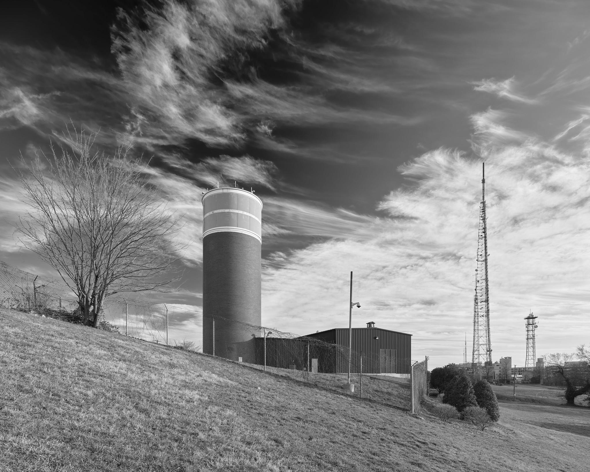
23 February 2020 The CARTWHEEL tower (center left) was built in the early 1960's as part of a hardened "continuity of government" microwave communications network spanning various presidential and other government emergency relocation facilities in parts of Maryland, Pennsylvania, Virginia, and West Virginia. Fort Reno, in the Tenleytown neighborhood of NW Washington, is at one of the highest elevations in the District. The (approximately) 100 foot hardened windowless concrete tower contains eight floors with offices, equipment rooms, maintenance shops, and a secure communications vault, all served by an elevator as well as a system of emergency ladders. Two additional levels at the top contain various microwave and VHF/UHF communications antennas; the antenna platforms are contained within a visually opaque plexiglass radome. Below ground there is a two story bunker with additional offices and living facilities. (The building to the immediate right is a recent addition and was not part of the original structure.) The (originally unmarked) tower was deliberately designed to be relatively inconspicuous, hiding in plain sight and easily mistaken for a water tower or agricultural silo by the uninitiated. In all, the network formed a semi-redundant ring of relays connecting the White House with the Mount Weather bunker (codename CRYSTAL), the Raven Rock Bunker (CREED), and Camp David (CACTUS), and was intended to be able to survive a limited nuclear strike (or so the theory went). CARTWHEEL, which was directly connected via microwave and underground cable to the White House (CROWN), served as the DC hub of the network. There were a total of at least seven semi-disguised "silo" towers of similar design in the network, mostly located in remote rural areas outside of DC. In addition to CARTWHEEL, CRYSTAL, CREED, and CACTUS, there were CORKSCREW (in Maryland), CANNONBALL (in Pennsylvania), and COWPUNCHER (in West Virginia). The network also included several mostly unmanned relay stations on conventional unhardened open towers, including sites on Quirauk Mountain, MD, near Mount Airy, MD, and in Tysons Corner, VA (known simply as "Site C", "Site D", and "Site E", respectively). The Presidential microwave network became redundant (supplanted by satellite links and other technologies) by the end of the cold war and was gradually deactivated in the 1980's. Most of the concrete towers were either demolished or fell into disrepair. CARTWHEEL (shown here) and CORKSCREW are now used by the FAA and remain well preserved. The Site C, Site D, and Site E towers are intact and remain in use by the military. The basic design (a concrete tower topped with a plexiglas radome) is somewhat similar to the earlier Western Union Tenleytown Tower located nearby (and visible at lower right in the photo); see www.flickr.com/photos/mattblaze/49576234678 . It seems plausible that the success of the Western Union tower influenced the design of CARTWHEEL and its siblings. Addendum: This page has some great first-hand information on the Presidential Emergency Facilities network, curated by someone who worked on it while at the White House Communications Agency. Rodenstock 23mm/5.6 Digaron-S lens (@ f/6,3), Phase One IQ4-150 back (@ ISO 50), Phase One XT camera (1/25 sec exposure). Full resolution available. . 000559



Captured with the Rodenstock 23mm/5.6 HR Digaron-S lens (@ f/6,3), Phase One IQ4-150 back (@ ISO 50), Phase One XT camera (1/25 sec exposure).
This unassuming cylindrical tower, at first glance perhaps a grain silo or water tower, was part of a secret "continuity of government" microwave communications network. Built in the early 1960's, a network of similar towers located around the capital region linked the White House with critical sites such as Camp David, Raven Rock, and Mount Weather.